addFeed( 1,
[ { title:'SPC MD 896', link:'https://www.spc.noaa.gov/products/md/md0896.html', description:'MD 0896 CONCERNING SEVERE POTENTIAL...WATCH POSSIBLE FOR CENTRAL AND EASTERN KANSAS
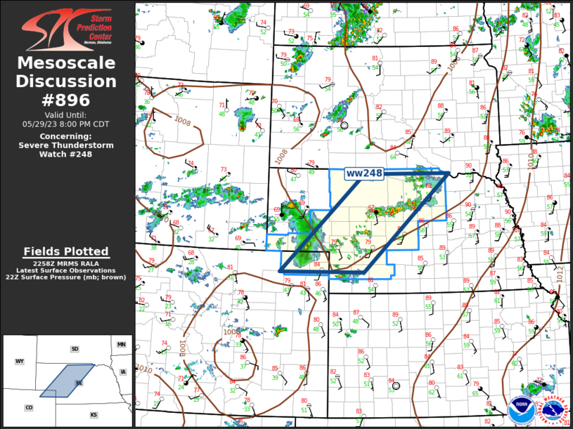
Mesoscale Discussion 0896NWS Storm Prediction Center Norman OK1119 PM CDT Mon May 19 2025Areas affected...Central and Eastern KansasConcerning...Severe potential...Watch possible Valid 200419Z - 200645ZProbability of Watch Issuance...40 percentSUMMARY...The severe threat may increase across central and easternKansas over the next few hours. Large hail and isolated wind damagewill be the primary threats.DISCUSSION...A couple areas of convection have intensified over thelast hour or so along a corridor from Salina southward to Wichita.This convection is being supported by a shortwave trough movingthrough the central Plains, evident on water vapor imagery. Ahead ofthe storms, an unstable airmass is present over much of east-centraland southeast Kansas. RAP forecast soundings near Emporia, Kansaslate this evening have a low-level temperature inversion, withMUCAPE around 2000 J/kg, and effective shear of 50 to 55 knots. Thisenvironment should be favorable for large hail. In spite of thelow-level temperature inversion, an isolated wind-damage threat mayalso develop with the faster and stronger downdrafts...Broyles/Gleason.. 05/20/2025...Please see www.spc.noaa.gov for graphic product...ATTN...WFO...TOP...ICT...LAT...LON 38929790 38649819 38069828 37649809 37319766 37229662 37309555 37809511 38489511 38959564 39099689 39029766 38929790 MOST PROBABLE PEAK TORNADO INTENSITY...UP TO 95 MPHMOST PROBABLE PEAK WIND GUST...55-70 MPHMOST PROBABLE PEAK HAIL SIZE...1.00-1.75 IN
Read more' }, { title:'SPC MD 895', link:'https://www.spc.noaa.gov/products/md/md0895.html', description:'MD 0895 CONCERNING TORNADO WATCH 297...298... FOR EASTERN MISSOURI...CENTRAL AND NORTHERN ARKANSAS...WESTERN ILLINOIS
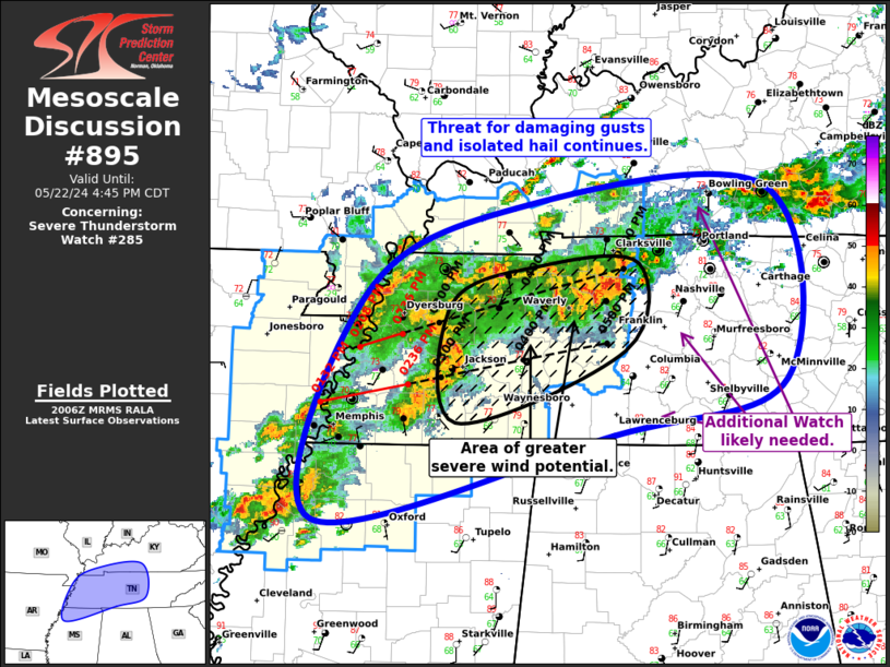
Mesoscale Discussion 0895NWS Storm Prediction Center Norman OK1042 PM CDT Mon May 19 2025Areas affected...Eastern Missouri...Central and NorthernArkansas...Western IllinoisConcerning...Tornado Watch 297...298...Valid 200342Z - 200545ZThe severe weather threat for Tornado Watch 297, 298 continues.SUMMARY...A severe threat will likely continue across parts ofcentral and northern Arkansas into parts of eastern Missouri andsouthwest Illinois. A severe threat may develop over parts ofeastern Arkansas. Weather watch issuance may be needed to the eastof WW 297.DISCUSSION...The latest mosaic radar imagery shows a line of strongto severe storms, located from central and northern Arkansasnorthward into southeast Missouri. Other severe storms are locatedin the vicinity of St Louis. Ahead of the line, moderate instabilityis analyzed by the RAP, with MLCAPE estimated in the 1500 to 2000J/kg range. In addition, the RAP has a 40 to 50 knot low-level jetlocated across eastern and central Arkansas, with the nose of thejet in southeast Missouri. This is creating strong low-level shear,which is sampled by the Little Rock WSR-88D VWP, which has 0-3 kmstorm-relative helicity near 400 m2/s2. This suggests that a tornadothreat will continue late this evening, with the threat maximizedwith rotating cells embedded in or ahead of the line. The potentialfor wind damage will be concentrated along the more intense parts ofthe line. The severe threat will increase as the line moves eastwardinto eastern Arkansas, where watch issuance may be needed...Broyles/Gleason.. 05/20/2025...Please see www.spc.noaa.gov for graphic product...ATTN...WFO...PAH...MEG...LSX...LZK...SGF...LAT...LON 34419338 34309273 34359183 34589111 35229043 36138977 37748917 38648909 39198953 39299038 39179094 39019118 38809137 38379149 37929170 37169193 36589223 35759294 35069376 34699380 34419338 MOST PROBABLE PEAK TORNADO INTENSITY...120-150 MPHMOST PROBABLE PEAK WIND GUST...65-80 MPHMOST PROBABLE PEAK HAIL SIZE...1.50-2.50 IN
Read more' }, { title:'SPC MD 897', link:'https://www.spc.noaa.gov/products/md/md0897.html', description:'MD 0897 CONCERNING SEVERE POTENTIAL...WATCH POSSIBLE FOR SOUTHEAST OKLAHOMA...NORTHEAST TEXAS

Mesoscale Discussion 0897NWS Storm Prediction Center Norman OK1140 PM CDT Mon May 19 2025Areas affected...Southeast Oklahoma...Northeast TexasConcerning...Severe potential...Watch possible Valid 200440Z - 200645ZProbability of Watch Issuance...60 percentSUMMARY...A severe threat may increase across parts of southeastOklahoma and northeast Texas. The primary threat will be hail andisolated wind damage.DISCUSSION...Over the last hour, convection has developed near theRed River to the north of the Dallas/Fort Worth Metroplex.Additionally, an isolated cell has developed further north insoutheast Oklahoma. These storms are located along an axis oflow-level moisture and instability, where surface dewpoints are fromthe upper 60s to mid 70s F, and MLCAPE is estimated by the RAP to befrom 1500 to 3000 J/kg. These storms are being supported by warmadvection, associated with a 40 to 50 knot low-level jet. Short-termmodel forecasts suggest that storm coverage will expand in coverage,as a nearly continuous line develops and moves eastward acrosssoutheast Oklahoma and northeast Texas. Hail and isolated winddamage will be the primary threats with these storms over the nextcouple of hours...Broyles/Gleason.. 05/20/2025...Please see www.spc.noaa.gov for graphic product...ATTN...WFO...SHV...TSA...FWD...OUN...LAT...LON 32599698 32599558 32919489 33669457 34249459 34869504 35019557 35029628 34669688 33759745 33189774 32839764 32599698 MOST PROBABLE PEAK TORNADO INTENSITY...85-115 MPHMOST PROBABLE PEAK WIND GUST...55-70 MPHMOST PROBABLE PEAK HAIL SIZE...1.00-1.75 IN
Read more' }, { title:'SPC Severe Thunderstorm Watch 299 Status Reports', link:'https://www.spc.noaa.gov/products/watch/ws0299.html', description:'WW 0299 Status Updates

STATUS FOR WATCH 0299 HAS NOT BEEN ISSUED YET
Read more' }, { title:'SPC Severe Thunderstorm Watch 299', link:'https://www.spc.noaa.gov/products/watch/ww0299.html', description:'WW 299 SEVERE TSTM AR OK TX 200500Z - 201000Z
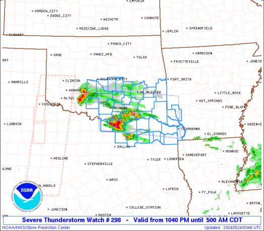
URGENT - IMMEDIATE BROADCAST REQUESTEDSevere Thunderstorm Watch Number 299NWS Storm Prediction Center Norman OK1200 AM CDT Tue May 20 2025The NWS Storm Prediction Center has issued a* Severe Thunderstorm Watch for portions of Far Western Arkansas Southern and Eastern Oklahoma North-Central Texas* Effective this Tuesday morning from Midnight until 500 AM CDT.* Primary threats include... Scattered large hail and isolated very large hail events to 2.5 inches in diameter possible Scattered damaging wind gusts to 70 mph possible A tornado or two possibleSUMMARY...Thunderstorms should continue to increase in coverage andintensity early this morning. Main threats should be large to verylarge hail, with the largest hailstones potentially reaching up to1.5-2.5 inches in diameter. Scattered severe/damaging winds may alsooccur if thunderstorms consolidate into a small bowing cluster.The severe thunderstorm watch area is approximately along and 45statute miles east and west of a line from 60 miles south of FortWorth TX to 35 miles west northwest of Fort Smith AR. For a completedepiction of the watch see the associated watch outline update(WOUS64 KWNS WOU9).PRECAUTIONARY/PREPAREDNESS ACTIONS...REMEMBER...A Severe Thunderstorm Watch means conditions arefavorable for severe thunderstorms in and close to the watch area.Persons in these areas should be on the lookout for threateningweather conditions and listen for later statements and possiblewarnings. Severe thunderstorms can and occasionally do producetornadoes.&&OTHER WATCH INFORMATION...CONTINUE...WW 297...WW 298...AVIATION...A few severe thunderstorms with hail surface and aloft to2.5 inches. Extreme turbulence and surface wind gusts to 60 knots. Afew cumulonimbi with maximum tops to 550. Mean storm motion vector26040....Gleason
Read more' }, { title:'SPC Tornado Watch 298 Status Reports', link:'https://www.spc.noaa.gov/products/watch/ws0298.html', description:'WW 0298 Status Updates
STATUS REPORT ON WW 298SEVERE WEATHER THREAT CONTINUES RIGHT OF A LINE FROM 30 NW ARG TO35 WNW POF TO 25 WSW FAM TO 35 ENE VIH TO 40 NE VIH TO 25 SSE UIN.FOR ADDITIONAL INFORMATION SEE MESOSCALE DISCUSSION 0895..GLEASON..05/20/25ATTN...WFO...PAH...LSX...SGF...STATUS REPORT FOR WT 298 SEVERE WEATHER THREAT CONTINUES FOR THE FOLLOWING AREAS ILC003-005-013-027-051-055-061-077-081-083-087-117-119-121-133-135-145-153-157-163-181-189-199-200540-IL . ILLINOIS COUNTIES INCLUDED AREALEXANDER BOND CALHOUN CLINTON FAYETTE FRANKLIN GREENE JACKSON JEFFERSON JERSEY JOHNSON MACOUPIN MADISON MARION MONROE MONTGOMERY PERRY PULASKI RANDOLPH ST. CLAIR UNION WASHINGTON WILLIAMSON MOC017-023-031-035-071-093-099-113-123-133-143-157-163-179-181-183-186-187-189-201-207-219-221-223-510-200540-MO . MISSOURI COUNTIES INCLUDED AREBOLLINGER BUTLER CAPE GIRARDEAU
Read more' }, { title:'SPC Tornado Watch 298', link:'https://www.spc.noaa.gov/products/watch/ww0298.html', description:'WW 298 TORNADO IL MO 200125Z - 200800Z
URGENT - IMMEDIATE BROADCAST REQUESTEDTornado Watch Number 298NWS Storm Prediction Center Norman OK825 PM CDT Mon May 19 2025The NWS Storm Prediction Center has issued a* Tornado Watch for portions of West-Central and Southern Illinois Southern into Central and Eastern Missouri* Effective this Monday night and Tuesday morning from 825 PM until 300 AM CDT.* Primary threats include... A few tornadoes likely with a couple intense tornadoes possible Widespread damaging winds likely with isolated significant gusts to 80 mph possible Scattered large hail and isolated very large hail events to 2 inches in diameter possibleSUMMARY...Multiple clusters and supercells will spread northeastwardthis evening and overnight while posing a threat for both tornadoesand severe/damaging winds. An intense/bowing line of thunderstormswill likely develop later this evening and pose a greater threat forwidespread severe winds, with peak gusts potentially reaching up to70-80 mph on an isolated basis. Occasional large hail up to 1-2inches in diameter may also occur with any semi-discrete supercells.The tornado watch area is approximately along and 110 statute mileseast and west of a line from 45 miles north northwest of Saint LouisMO to 20 miles southeast of West Plains MO. For a complete depictionof the watch see the associated watch outline update (WOUS64 KWNSWOU8).PRECAUTIONARY/PREPAREDNESS ACTIONS...REMEMBER...A Tornado Watch means conditions are favorable fortornadoes and severe thunderstorms in and close to the watcharea. Persons in these areas should be on the lookout forthreatening weather conditions and listen for later statementsand possible warnings.&&OTHER WATCH INFORMATION...CONTINUE...WW 294...WW 295...WW296...WW 297...AVIATION...Tornadoes and a few severe thunderstorms with hailsurface and aloft to 2 inches. Extreme turbulence and surface windgusts to 70 knots. A few cumulonimbi with maximum tops to 550. Meanstorm motion vector 24035....Gleason
Read more' }, { title:'SPC Tornado Watch 297 Status Reports', link:'https://www.spc.noaa.gov/products/watch/ws0297.html', description:'WW 0297 Status Updates
STATUS REPORT ON WW 297SEVERE WEATHER THREAT CONTINUES RIGHT OF A LINE FROM 10 SSE ADMTO 20 NE DEQ TO RUE TO 40 ENE RUE TO 35 W BVX TO 25 ESE FLP TO 25ESE UNO.FOR ADDITIONAL INFORMATION SEE MESOSCALE DISCUSSION 0895..GLEASON..05/20/25ATTN...WFO...LZK...TSA...SHV...OUN...STATUS REPORT FOR WT 297 SEVERE WEATHER THREAT CONTINUES FOR THE FOLLOWING AREAS ARC023-029-045-049-051-057-061-063-065-067-075-081-085-091-097-105-109-113-115-117-119-121-125-133-135-137-141-145-147-149-200540-AR . ARKANSAS COUNTIES INCLUDED ARECLEBURNE CONWAY FAULKNER FULTON GARLAND HEMPSTEAD HOWARD INDEPENDENCE IZARD JACKSON LAWRENCE LITTLE RIVER LONOKE MILLER MONTGOMERY PERRY PIKE POLK POPE PRAIRIE PULASKI RANDOLPH SALINE SEVIER SHARP STONE VAN BUREN WHITE WOODRUFF YELL OKC013-023-089-200540-OK
Read more' }, { title:'SPC Tornado Watch 297', link:'https://www.spc.noaa.gov/products/watch/ww0297.html', description:'WW 297 TORNADO AR OK TX 192350Z - 200700Z
URGENT - IMMEDIATE BROADCAST REQUESTEDTornado Watch Number 297NWS Storm Prediction Center Norman OK650 PM CDT Mon May 19 2025The NWS Storm Prediction Center has issued a* Tornado Watch for portions of Western and Northern Arkansas Southeast and Eastern Oklahoma Far Northeast Texas* Effective this Monday night and Tuesday morning from 650 PM until 200 AM CDT.* Primary threats include... Several tornadoes and a couple intense tornadoes likely Widespread large hail and scattered very large hail events to 3.5 inches in diameter likely Widespread damaging winds and isolated significant gusts to 80 mph likelySUMMARY...Multiple supercells and clusters will spread northeastwardthis evening and into the early overnight hours. Several tornadoesappear likely given a rather favorable environment for severethunderstorms, and a couple of these should be strong to intense(EF2-3+). Some upscale growth is anticipated later this evening,with an increasing threat for numerous to widespread severe/damagingwinds. Peak gusts may reach up to 70-80 mph. Large hail up to2.5-3.5 inches in diameter also appears likely with embeddedsupercells.The tornado watch area is approximately along and 95 statute mileseast and west of a line from 50 miles east southeast of Durant OK to20 miles northeast of Harrison AR. For a complete depiction of thewatch see the associated watch outline update (WOUS64 KWNS WOU7).PRECAUTIONARY/PREPAREDNESS ACTIONS...REMEMBER...A Tornado Watch means conditions are favorable fortornadoes and severe thunderstorms in and close to the watcharea. Persons in these areas should be on the lookout forthreatening weather conditions and listen for later statementsand possible warnings.&&OTHER WATCH INFORMATION...CONTINUE...WW 292...WW 293...WW294...WW 295...WW 296...AVIATION...Tornadoes and a few severe thunderstorms with hailsurface and aloft to 3.5 inches. Extreme turbulence and surface windgusts to 70 knots. A few cumulonimbi with maximum tops to 600. Meanstorm motion vector 24035....Gleason
Read more' }, { title:'SPC Severe Thunderstorm Watch 296 Status Reports', link:'https://www.spc.noaa.gov/products/watch/ws0296.html', description:'WW 0296 Status Updates

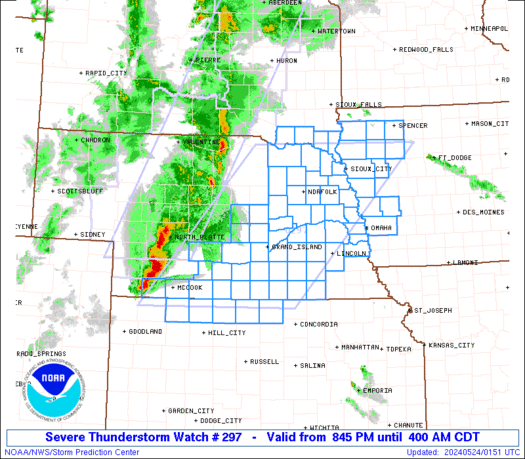
STATUS REPORT ON WW 296SEVERE WEATHER THREAT CONTINUES RIGHT OF A LINE FROM 20 N STJ TO30 NNW LWD TO 35 N OTM...BROYLES..05/20/25ATTN...WFO...DMX...EAX...STATUS REPORT FOR WS 296 SEVERE WEATHER THREAT CONTINUES FOR THE FOLLOWING AREAS IAC007-039-051-053-117-123-125-135-159-179-185-200340-IA . IOWA COUNTIES INCLUDED AREAPPANOOSE CLARKE DAVIS DECATUR LUCAS MAHASKA MARION MONROE RINGGOLD WAPELLO WAYNE MOC001-041-053-079-081-089-115-121-129-171-175-197-211-200340-MO . MISSOURI COUNTIES INCLUDED AREADAIR CHARITON COOPER GRUNDY HARRISON HOWARD LINN MACON MERCER PUTNAM RANDOLPH SCHUYLER SULLIVAN THE WATCH STATUS MESSAGE IS FOR GUIDANCE PURPOSES ONLY. PLEASEREFER TO WATCH COUNTY NOTIFICATION STATEMENTS FOR OFFICIAL
Read more' }, { title:'SPC Center Public Severe Weather Outlook (PWO)', link:'https://www.spc.noaa.gov/products/outlook/pwo.html', description:'Public Severe Weather Outlook
PUBLIC SEVERE WEATHER OUTLOOK NWS STORM PREDICTION CENTER NORMAN OK0840 PM CDT MON MAY 19 2025...Severe thunderstorms expected over parts of the southern Plainsinto the Ozarks and mid Mississippi Valley this evening andovernight...* LOCATIONS... Western and Northern Arkansas Missouri Far Eastern Oklahoma North-Central and Northeast Texas Southern Illinois* HAZARDS... Widespread damaging winds, some hurricane force Several tornadoes, a few intense Scattered large hail, some baseball size* SUMMARY... A significant severe weather episode should continue tonight across parts of the South-Central States. Strong tornadoes, scattered to widespread damaging wind swaths, and very large hail remain possible.Preparedness actions...Tornadoes at night can be particularly dangerous because they are usually fast-moving and difficult to see. Stay tuned toNOAA Weather Radio, weather.gov, or other media for watches andwarnings. A tornado watch means that conditions are favorablefor tornadoes to form during the next several hours. If a tornadowarning is issued for your area, move to a place of safety,ideally in a basement or interior room on the lowest floor of asturdy building.
Read more' }, { title:'SPC Tornado Watch 294 Status Reports', link:'https://www.spc.noaa.gov/products/watch/ws0294.html', description:'WW 0294 Status Updates

STATUS REPORT ON WW 294SEVERE WEATHER THREAT CONTINUES RIGHT OF A LINE FROM 45 SE SZL TO30 W SZL TO 25 W OJC TO 20 NE FLV TO 25 SE SDA...BROYLES..05/20/25ATTN...WFO...ICT...TOP...EAX...SGF...STATUS REPORT FOR WT 294 SEVERE WEATHER THREAT CONTINUES FOR THE FOLLOWING AREAS KSC091-209-200340-KS . KANSAS COUNTIES INCLUDED AREJOHNSON WYANDOTTE MOC003-025-033-047-049-061-063-075-095-101-107-117-147-159-177-195-227-200340-MO . MISSOURI COUNTIES INCLUDED AREANDREW CALDWELL CARROLL CLAY CLINTON DAVIESS DEKALB GENTRY JACKSON JOHNSON LAFAYETTE LIVINGSTON NODAWAY PETTIS RAY SALINE WORTH THE WATCH STATUS MESSAGE IS FOR GUIDANCE PURPOSES ONLY. PLEASEREFER TO WATCH COUNTY NOTIFICATION STATEMENTS FOR OFFICIALINFORMATION ON COUNTIES...INDEPENDENT CITIES AND MARINE ZONES
Read more' }, { title:'SPC Tornado Watch 295 Status Reports', link:'https://www.spc.noaa.gov/products/watch/ws0295.html', description:'WW 0295 Status Updates

STATUS REPORT ON WW 295SEVERE WEATHER THREAT CONTINUES RIGHT OF A LINE FROM 20 E PRX TO35 N FTW TO 35 SW ADM.FOR ADDITIONAL INFORMATION SEE MESOSCALE DISCUSSION 0892..WEINMAN..05/20/25ATTN...WFO...FWD...STATUS REPORT FOR WT 295 SEVERE WEATHER THREAT CONTINUES FOR THE FOLLOWING AREAS TXC097-147-181-277-200240-TX . TEXAS COUNTIES INCLUDED ARECOOKE FANNIN GRAYSON LAMAR THE WATCH STATUS MESSAGE IS FOR GUIDANCE PURPOSES ONLY. PLEASEREFER TO WATCH COUNTY NOTIFICATION STATEMENTS FOR OFFICIALINFORMATION ON COUNTIES...INDEPENDENT CITIES AND MARINE ZONESCLEARED FROM SEVERE THUNDERSTORM AND TORNADO WATCHES.
Read more' }, { title:'SPC May 20, 2025 0100 UTC Day 1 Convective Outlook', link:'https://www.spc.noaa.gov/products/outlook/day1otlk_0100.html', description:'SPC 0100Z Day 1 Outlook

Day 1 Convective Outlook NWS Storm Prediction Center Norman OK0759 PM CDT Mon May 19 2025Valid 200100Z - 201200Z...THERE IS A MODERATE RISK OF SEVERE THUNDERSTORMS IN NORTHWESTARKANSAS...SOUTHWEST MISSOURI...AND FAR EASTERN OKLAHOMA......SUMMARY...A significant severe weather episode should continue tonight acrossparts of the South-Central States. Strong tornadoes, scattered towidespread damaging wind swaths, and very large hail remainpossible....TX/OK to the Mid-MS/Lower OH Valley...While extensive overturning has already occurred, there are severalprimary areas of concern for severe storms tonight. In thenear-term, the greatest tornado/wind potential should exist with apair of supercells embedded within a broadsouthwest/northeast-oriented QLCS from the Ozark Plateau to the RedRiver. With the most pronounced low-level shear ahead of thisportion of the QLCS, strong tornado and significant severe windpotential should persist into late evening. Despite strongerlarge-scale ascent focused west, the organized nature of the QLCSsuggests that embedded wind gusts of 60-75 mph could produce apotentially widespread damaging wind swath that may persisteast-northeast overnight. Have expanded outlook categories farthereast across the Mid-MS/Lower OH Valley.The trailing portion of the QLCS has been stubborn to accelerateeast, but should begin to do so in the next couple hours. Short-termguidance has been insistent on additional convection developing backwest with strengthening ascent ahead of the primary shortwave troughfrom central to eastern OK tonight. This could pose another round ofsevere hail/wind threat persisting into the early morning....KS and the Lower/Mid-MO Valley...Scattered severe storms should generally wane during the lateevening. But similar to the OK redevelopment, post-dryline/frontalhigh-based convection should expand east-northeast and likelyimpinge on lingering strong to severe storms across eastern KS. Thiscould maintain at least isolated severe storms lingering overnight...Grams.. 05/20/2025
Read more' }, { title:'SPC Tornado Watch 293 Status Reports', link:'https://www.spc.noaa.gov/products/watch/ws0293.html', description:'WW 0293 Status Updates
STATUS REPORT ON WW 293SEVERE WEATHER THREAT CONTINUES RIGHT OF A LINE FROM 5 WNW BIE TO30 NNE LNK TO 15 WSW TQE...BROYLES..05/20/25ATTN...WFO...OAX...GID...STATUS REPORT FOR WT 293 SEVERE WEATHER THREAT CONTINUES FOR THE FOLLOWING AREAS IAC071-129-137-145-155-200140-IA . IOWA COUNTIES INCLUDED AREFREMONT MILLS MONTGOMERY PAGE POTTAWATTAMIE NEC025-055-067-097-109-127-131-133-147-153-155-177-200140-NE . NEBRASKA COUNTIES INCLUDED ARECASS DOUGLAS GAGE JOHNSON LANCASTER NEMAHA OTOE PAWNEE RICHARDSON SARPY SAUNDERS WASHINGTON THE WATCH STATUS MESSAGE IS FOR GUIDANCE PURPOSES ONLY. PLEASEREFER TO WATCH COUNTY NOTIFICATION STATEMENTS FOR OFFICIALINFORMATION ON COUNTIES...INDEPENDENT CITIES AND MARINE ZONESCLEARED FROM SEVERE THUNDERSTORM AND TORNADO WATCHES.
Read more' } ] );